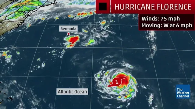
VietPress USA (Sept. 10, 2018): Today on Monday, Sept. 10, Gov. Henry McMaster on Monday mandated that, beginning Tuesday, eight counties along the coast — Horry, Georgetown, Charleston, Dorchester, Berkeley, Colleton, Beaufort and Jasper — must evacuate by no later than noon.
South Carolina residents have been ordered to evacuate from the coast as the state prepares for Hurricane Florence to make landfall later this week.
Florence exploded into a potentially catastrophic Category 4 hurricane Monday as it closed in on North and South Carolina, carrying winds up to 130 mph and water that could wreak havoc over a wide stretch of the eastern United States later this week.
Communities along a stretch of coastline that's vulnerable to rising sea levels due to climate change prepared to evacuate the storm, which forecasters expect to be close to Category 5 strength by Tuesday. The South Carolina governor ordered the state's entire coastline to be evacuated starting at noon Tuesday and predicted that 1 million people would flee. And Virginia's governor ordered a mandatory evacuation for some residents of low-lying coastal areas.
The storm's first effects were already apparent on barrier islands as dangerous rip currents hit beaches and seawater flowed over a state highway.
VietPress USA News
oOo
Florence strengthens to Category 4, takes aim at Carolinas
Communities along a stretch of coastline that's vulnerable to rising sea levels due to climate change prepared to evacuate the storm, which forecasters expect to be close to Category 5 strength by Tuesday. The South Carolina governor ordered the state's entire coastline to be evacuated starting at noon Tuesday and predicted that 1 million people would flee. And Virginia's governor ordered a mandatory evacuation for some residents of low-lying coastal areas.
The storm's first effects were already apparent on barrier islands as dangerous rip currents hit beaches and seawater flowed over a state highway.
For many people, the challenge could be finding a safe refuge: If Florence slows to a crawl just off the coast, it could bring torrential rains to the Appalachian mountains and as far away as West Virginia, causing flash floods, mudslides and other dangerous conditions.
The storm's potential path also includes half a dozen nuclear power plants, pits holding coal-ash and other industrial waste, and numerous hog farms that store animal waste in massive open-air lagoons.
Airlines, including American and Southwest, have started letting passengers change travel plans that take them into the hurricane's possible path.
National Hurricane Center Director Ken Graham warned that Florence was forecast to linger over the Carolinas once it reaches shore. People living well inland should prepare to lose power and endure flooding and other hazards, he warned.
"It's not just the coast," Graham said. "When you stall a system like this and it moves real slow, some of that rainfall can extend well away from the center."
A warm ocean is the fuel that powers hurricanes, and Florence will be moving over waters where temperatures are peaking near 85 degrees (30 Celsius), hurricane specialist Eric Blake wrote. And with little wind shear to pull the storm apart, Florence's hurricane wind field was expected to expand over the coming days, increasing its storm surge and inland wind threats.
By 5 p.m. Monday, Florence was centered about 1,170 miles (1,880 kilometers) east-southeast of Cape Fear, North Carolina, and moving west at 13 mph (20 kph). Its center will move between Bermuda and the Bahamas on Tuesday and Wednesday and approach the coast of South Carolina or North Carolina on Thursday, the National Hurricane Center said.
Two other storms were spinning in the Atlantic. Hurricane Isaac was expected to lose strength as it reaches the Caribbean, and Helene, much farther out to sea, may veer northward into the open ocean as the 2018 hurricane season reaches its peak.
In the Pacific, Hurricane Olivia triggered warnings for multiple Hawaiian islands as it blew west toward an arrival over the state as soon as late Tuesday or early Wednesday.
Preparations for Florence were intensifying up and down the densely populated coast. Since reliable record-keeping began more than 150 years ago, North Carolina has been hit by only one Category 4 hurricane: Hazel, with 130 mph winds, in 1954.
The parking lot has been full for three days at the Ace Hardware store in coastal Calabash, North Carolina, where manager Tom Roberts said he sold 150 gas cans in two hours Monday, along with generators, plywood, rope, manual can openers, sand bags and a plethora of other items.
"I've been doing this since 1983," Roberts said as he completed an order for another 18-wheeler full of supplies. "This is the craziest one."
Many newcomers have moved to the coast in the nearly 19 years since the last strong hurricane — Floyd — threatened the area. Roberts said he's telling them to get out of town.
"I'm telling them to go inland, but I'm worried about the rain and tornadoes too," Roberts said.
Several meteorologists said Florence could do what Hurricane Harvey did last year over Texas, dumping days of rain, although not quite as bad.
"I think this is very Harvey-esque," said University of Miami hurricane expert Brian McNoldy. "Normally, a landfalling tropical cyclone just keeps on going inland, gradually dissipating and raining itself out. But on rare occasions, the steering patterns can line up such that a storm slips into a dead zone between troughs and ridges."
oOo
Hạnh Dương
www.Vietpressusa.us

